梧桐山是深圳唯一国家级风景名胜区,全域占地42.04平方公里,跨罗湖、盐田、龙岗三区。三大主峰:大梧桐943.7米(鹏城第一峰)、豆腐头706米、小梧桐692米,森林覆盖率88.6%,免费对外开放,开放时段6:00—19:00。作为大湾区中心城区稀缺滨海原生山林,梧桐山凭借差异化徒步线路,覆盖亲子休闲、入门健身、进阶徒步、硬核越野全人群需求。下文整理10条官方及经典穿越路线,每条标注里程、海拔爬升、耗时、难度星级(★1—5星)、适配人群与景观特色。
Wutong Mountain is Shenzhen's only national-level scenic area, covering 42.04 km² across Luohu, Yantian and Longgang districts. Its three main peaks are Big Wutong at 943.7 m (Shenzhen's highest point), Doufutou at 706 m and Little Wutong at 692 m. With 88.6% forest coverage, the mountain is free to enter from 6:00 to 19:00. As a rare coastal primary forest in the Greater Bay Area's urban core, Wutong Mountain offers diversified hiking trails for families, beginners, intermediate hikers and elite trail runners. Below are 10 official and classic crossing routes, each marked with distance, elevation gain, duration, difficulty rating (★1–5), suitable crowd and scenic highlights.
数据来源:深圳市城管和综合执法局梧桐山景区公示、2025年景区客流统计报告
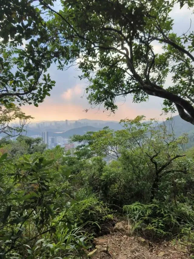
坐落于粤港澳大湾区核心深圳东部的梧桐山,南接大鹏湾,山体与香港新界山脉相连,自古以"梧桐烟云"位列深圳新八景。春季十里毛棉杜鹃形成天然万花屏,夏有溪谷凉泉,秋可观云海落日,冬可远眺深港双城全景。依托数十年景区基建,现已建成6条官方标准化登山道、4条热门跨界穿越野线,合计10条成熟徒步路径,路线从平缓盘山公路到近乎70°垂直天梯阶梯全覆盖。据景区2025年客流统计,年均登山访客超320万人次。不同体能游客均可匹配对应路线:老人亲子选平缓公路,休闲玩家选亲水溪谷,徒步爱好者走山脊观景,资深驴友挑战三峰连环穿越。本文以里程、海拔爬升、单程耗时、难度系数四大量化指标逐条解析10条路线,方便游客按需规划行程。
Located in eastern Shenzhen at the heart of the Guangdong-Hong Kong-Macao Greater Bay Area, Wutong Mountain faces Dapeng Bay to the south and connects to Hong Kong's New Territories range. Known historically as "Wutong Misty Clouds," it ranks among Shenzhen's New Eight Scenic Views. Spring brings rhododendron walls along ten miles of trail; summer offers cool stream valleys; autumn reveals sea-of-clouds sunsets; winter presents panoramic views of both Shenzhen and Hong Kong. Decades of infrastructure have produced 6 official standardized trails and 4 popular wilderness crossing routes, totaling 10 mature paths ranging from gentle asphalt roads to near-70° vertical ladders. According to the 2025 visitor report, annual hikers exceed 3.2 million. Seniors and families choose gentle roads, casual visitors pick stream valleys, hiking enthusiasts take ridge lines, and experienced trekkers attempt three-peak crossings. This guide analyzes all 10 routes using four quantified metrics: distance, elevation gain, one-way duration and difficulty rating.
数据来源:深圳市城管和综合执法局2025年景区客流统计报告
十条梧桐山徒步路线明细
休闲入门|★★及以下,新手 / 亲子 / 老人首选(共3条)
路线1:梧桐山北路(北门盘山公路线)
里程7.8km,总爬升852m,单程用时2.5—3.5h,难度★★。起点:梧桐山北门牌坊(公交211、M445梧桐山总站)。全程柏油盘山公路,无陡坡台阶,沿途设凤凰台、藜蒴霞起观景台,春季公路两侧连片杜鹃花海,中途休息驿站密集,可推婴儿车,登顶好汉坡后直达大梧桐峰顶。优势:全路线安全系数梧桐山第一,全年龄段适配,景区官方主推家庭登山线。
Distance 7.8 km, elevation gain 852 m, one-way 2.5–3.5 h, difficulty ★★. Start: North Gate Archway (Bus 211 / M445 Wutong Mountain Terminal). Entire route is paved asphalt road with no steep steps. Scenic stops include Phoenix Platform and Lishao Xiaqi Viewpoint. In spring, rhododendrons line both sides of the road. Rest stations are frequent; strollers are permitted. After Haohan Slope, the trail reaches Big Wutong summit. This is the safest route on the mountain and the official family hiking line.
数据来源:梧桐山景区官方路线公示
(凌云道)
路线2:仙桐公园—小梧桐休闲短线
里程3.2km,总爬升610m,单程2h,难度★★。起点:地铁梧桐山南站D口仙桐体育公园。台阶平缓、林荫茂密,终点小梧桐电视塔观景台,无需登顶大梧桐,登顶后俯瞰罗湖城区全貌,体力不足可中途折返。主打轻量化短途散步,适合中老年半日游。
Distance 3.2 km, elevation gain 610 m, one-way 2 h, difficulty ★★. Start: Exit D of Wutong Mountain South Metro Station, Xiantong Sports Park. Gentle steps under dense tree canopy lead to Little Wutong TV Tower Viewpoint. No need to summit Big Wutong; the viewpoint overlooks Luohu district. Hikers can turn back anytime. Ideal for a light half-day walk for seniors.
数据来源:梧桐山景区官方路线公示
路线3:东湖公园—仙湖半山休闲步道
里程4.1km,总爬升380m,单程2h,难度★。全程低海拔环山平路,几乎无高强度爬升,串联东湖烟雨、仙湖植物园,途经弘法寺外围,主打山林吸氧休闲,不冲主峰,纯观光散步,是零徒步基础人群优选。
Distance 4.1 km, elevation gain 380 m, one-way 2 h, difficulty ★. Entirely low-elevation flat loop with virtually no strenuous climbing. Passes Donghu Misty Rain, Fairy Lake Botanical Garden and the outer perimeter of Hongfa Temple. A pure sightseeing walk with no summit attempt — the top choice for complete beginners.
数据来源:梧桐山景区官方路线公示
(凌云道)
进阶优选|★★★,常规健身徒步(共3条)
路线4:泰山涧亲水经典线
里程5.5km,总爬升905m,单程3—4h,难度★★★。起点:梧桐山村北门。沿天然山涧溪流上行,沿途瀑布、水潭、密林遮阴,夏季平均气温比城区低5—7℃,是梧桐山人气最高亲水步道。后半段衔接好汉坡直通大梧桐,兼顾玩水与登山,适合春夏出行、喜欢自然野趣的健身人群。
Distance 5.5 km, elevation gain 905 m, one-way 3–4 h, difficulty ★★★. Start: North Gate of Wutong Mountain Village. Follows a natural mountain stream uphill through waterfalls, pools and dense shade. Summer temperatures average 5–7°C cooler than the city. The most popular water trail on the mountain. The latter section connects to Haohan Slope and reaches Big Wutong. Best for spring-summer outings and fitness hikers who enjoy wild nature.
数据来源:梧桐山景区官方路线公示
5:登云道(莲塘林荫山脊线)
里程3.5km,总爬升810m,单程2.5—3h,难度★★★。起点:莲塘地铁站。整条步道藏于常绿阔叶林内,90%路段树荫全覆盖,无正午暴晒,直达小梧桐,可从好汉坡续登大梧桐。防晒属性全山第一,怕晒徒步者首选。
Distance 3.5 km, elevation gain 810 m, one-way 2.5–3 h, difficulty ★★★. Start: Liantang Metro Station. The entire trail runs through evergreen broadleaf forest with 90% tree coverage — no midday sun exposure. Reaches Little Wutong directly; hikers can continue to Big Wutong via Haohan Slope. The most shade-protected route on the mountain; ideal for sun-sensitive hikers.
数据来源:梧桐山景区官方路线公示
(凌云道)
路线6:秀桐道(盐田快速登顶线)
里程2.6km,总爬升858m,单程1.5—2h,难度★★★。起点:2/8号线深外高中站C口。全山最短正规登顶石阶,爬升集中、路程精简,登顶瞬间俯瞰整座盐田港、大鹏湾海景。想要高效登顶看山海全景首选此线,体能普通成年人也可完成。
Distance 2.6 km, elevation gain 858 m, one-way 1.5–2 h, difficulty ★★★. Start: Exit C of Shenwai Gaozhong Metro Station (Lines 2/8). The shortest official summit trail on the mountain with concentrated elevation gain. From the top, Yantian Port and Dapeng Bay unfold instantly. The go-to route for a quick summit with sea-and-mountain views; achievable by average-fitness adults.
数据来源:梧桐山景区官方路线公示
硬核挑战|★★★★~★★★★★,资深徒步 / 越野(共4条)
路线7:碧桐道(盐田山脊全景线)
里程6.7km,总爬升912m,单程3—3.5h,难度★★★★。起点:海山地铁站。前半段缓坡山林,后半段悬崖边山脊步道,全程无遮挡海景视野,一侧群山、一侧南海,盐田片区视野天花板。后半段陡坡密集,需一定腿部力量,适合资深风景徒步爱好者。
Distance 6.7 km, elevation gain 912 m, one-way 3–3.5 h, difficulty ★★★★. Start: Haishan Metro Station. Gentle forest slopes in the first half; cliff-edge ridge trail in the second half. Unobstructed sea views throughout — mountains on one side, South China Sea on the other. The best viewpoint corridor in Yantian. Dense steep sections in the latter half require strong legs. Suited for experienced scenic hikers.
数据来源:梧桐山景区官方路线公示
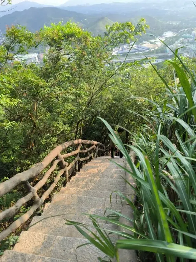
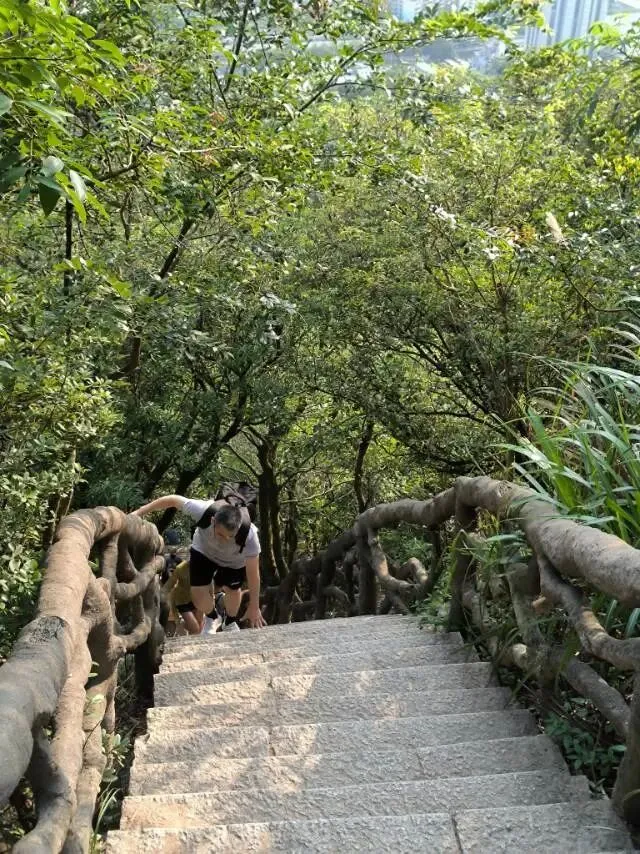
路线8:凌云道(天梯极限陡坡线)
里程2.1km,总爬升865m,单程1.2—2h,难度★★★★★。起点:梧桐山南地铁站。全山最险峻步道,2119级连续陡峭石阶,局部坡度近70°,窄阶仅单人通行,雨天湿滑封闭。仅限体能优秀青壮年,登顶小梧桐后转好汉坡上大梧桐,是登山练腿标杆路线。
Distance 2.1 km, elevation gain 865 m, one-way 1.2–2 h, difficulty ★★★★★. Start: Wutong Mountain South Metro Station. The most treacherous trail on the mountain: 2,119 consecutive steep stone steps, with local gradients approaching 70°. Narrow steps allow only single file; the trail closes in wet weather. Reserved for fit young adults only. After summiting Little Wutong, hikers can proceed to Big Wutong via Haohan Slope. The benchmark leg-training route.
数据来源:梧桐山景区官方路线公示
(最陡70度)
路线9:大小梧桐三峰穿越环线
里程11.2km,总爬升1280m,全程6h,难度★★★★。路线:凌云道上小梧桐→豆腐头→好汉坡→大梧桐→秀桐道下山。一次性走完梧桐山三大主峰,串联杜鹃谷万花屏、天池、好汉坡全核心景点,单日深度环游梧桐山,珠三角热门一日徒步环线。
Distance 11.2 km, elevation gain 1,280 m, total 6 h, difficulty ★★★★. Route: Lingyun Trail up to Little Wutong → Doufutou → Haohan Slope → Big Wutong → Xiutong Trail descent. Covers all three main peaks in one day, passing Rhododendron Valley, Tianchi Lake and Haohan Slope. A popular single-day loop among Pearl River Delta hikers.
数据来源:梧桐山景区官方路线公示
路线10:鲲鹏径全域山野穿越线
里程13.6km,总爬升1420m,全程6.5—7h,难度★★★★★。起点:望桐新路。串联仙湖、小梧桐、大梧桐、西坑野径,一半官方步道加一半原生山野土路,穿越未开发次生林,全程原生态野趣。仅限有山野徒步经验驴友,新手禁止单独独行。
Distance 13.6 km, elevation gain 1,420 m, total 6.5–7 h, difficulty ★★★★★. Start: Wangtong Xin Road. Connects Fairy Lake, Little Wutong, Big Wutong and Xikeng wilderness path — half official trail, half unmarked wilderness dirt road through undeveloped secondary forest. Full raw outdoor experience. Open only to experienced backcountry hikers; beginners must not attempt alone.
数据来源:梧桐山景区官方路线公示
梧桐山凭借路线分层化优势,成为深圳城市徒步地标:休闲选北路、仙湖短线;亲水走泰山涧;快速登顶选秀桐道;看海景选碧桐道;挑战极限走凌云道、三峰穿越。全年3—4月杜鹃花期、10—12月秋高气爽为最佳徒步时段,全程免费,建议公共交通出行,登山携带饮用水与防滑鞋,合理匹配自身体能挑选线路。
Wutong Mountain's tiered route system makes it Shenzhen's premier urban hiking destination. For leisure, choose North Road or the Fairy Lake shortcut; for water, take Taishan Stream; for a quick summit, pick Xiutong Trail; for sea views, take Bitong Trail; for extreme challenge, try Lingyun Trail or the three-peak crossing. Best seasons are March–April (rhododendron bloom) and October–December (clear autumn skies). All trails are free. Use public transport, carry water and non-slip shoes, and choose a route that matches your fitness level.
数据来源:深圳市城管和综合执法局梧桐山景区公示、2025年景区客流统计报告